Infrastructure Drone Inspection & Survey
Vertex Air provides specialist drone based inspection and survey services for critical infrastructure assets across the UK. From bridges and railway structures to powerlines, pipelines, and telecoms assets, our survey teams deploy advanced UAV technology to capture detailed visual, LiDAR, and thermal data delivering comprehensive condition and geometric information without the disruption, cost, and risk associated with conventional inspection methods.
Our Infrastructure Drone Capabilities
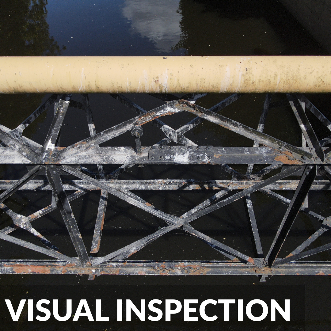
High resolution 4K imagery and video of structural components, surfaces, and joints captured from a safe operational distance. Geo-referenced imagery identifying defects and deterioration across the full extent of the asset without access equipment or working at height.
Precise point cloud data and 3D models of infrastructure assets, suitable for structural assessment, CAD drawing production, and BIM integration. Surveys conducted without lane closures or possession windows in the majority of cases.
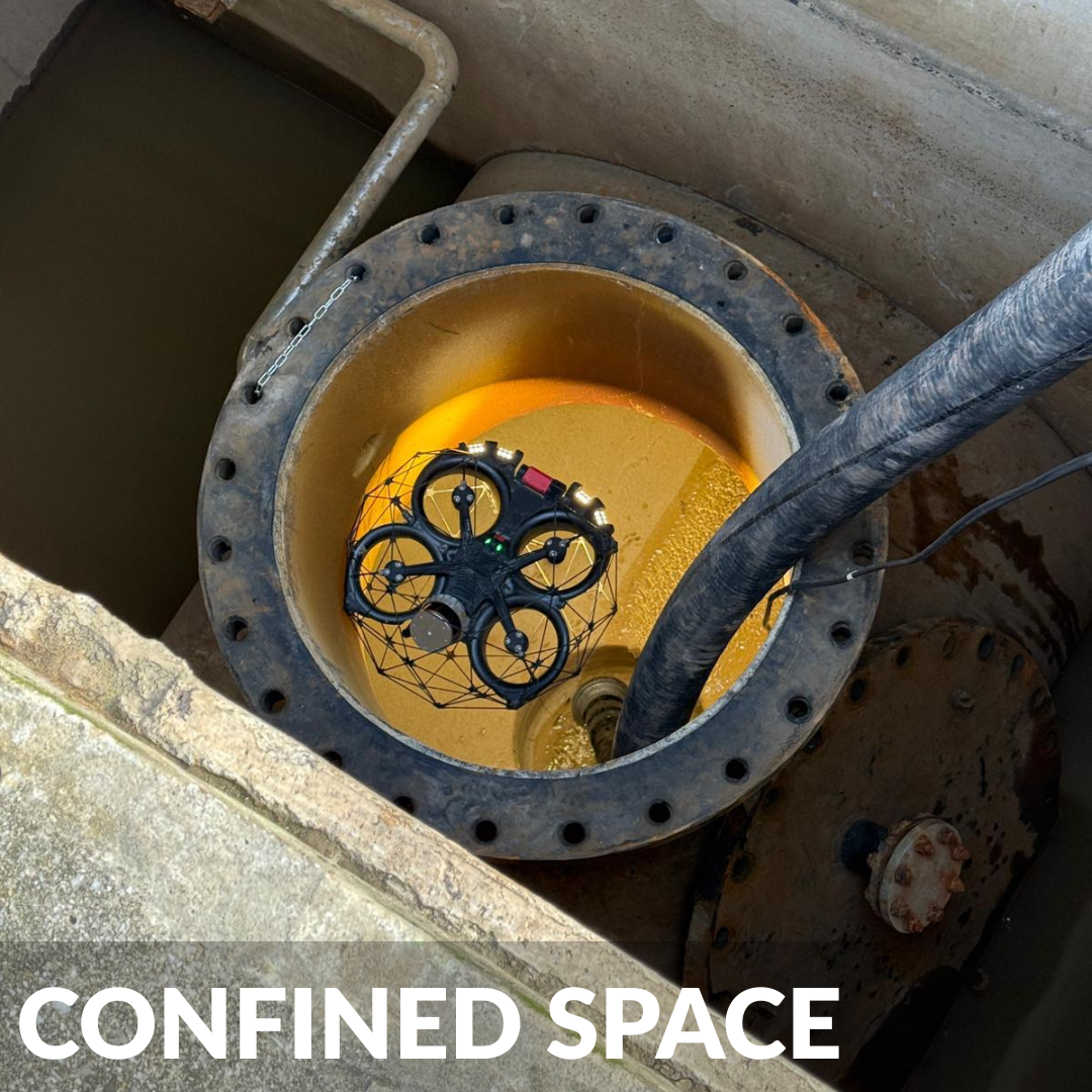
Where infrastructure assets contain internal voids chambers, and tunnel sections the Flyability Elios 3 provides internal inspection capability alongside the external survey, delivering a complete structural assessment from a single mobilisation.
Rapid deployment for post incident condition assessment following storm damage, vehicle strikes, or structural failures. Immediate aerial survey delivering high resolution imagery and condition data to engineers and asset managers without putting personnel into unsafe environments.
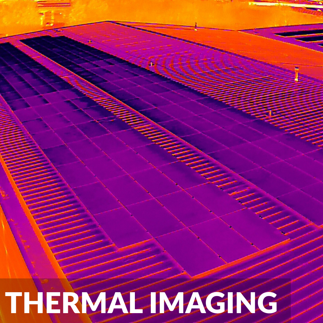
Radiometric thermal cameras identify heat anomalies, electrical faults, moisture ingress, and material defects that visual inspection alone cannot capture. Particularly relevant for powerline inspection, pipeline leak detection, and identifying subsurface moisture in highway and rail structures.
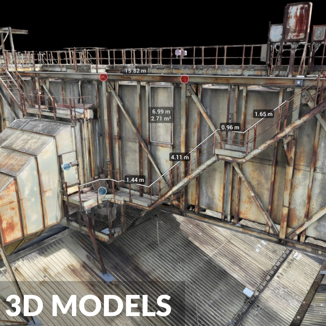
High resolution photogrammetry models produced from aerial imagery delivering precise, measurable digital records of infrastructure assets. Compatible with CAD, BIM, and GIS workflows and suitable for as built documentation, deformation monitoring, and maintenance planning.
A More Effective Approach to Infrastructure Inspection
Conventional infrastructure inspection methods such as scaffolding, rope access, mobile elevated work platforms, lane closures, and possession windows carry significant cost and programme implications. For assets on operational railway lines, busy highway networks, or in remote and inaccessible locations, the logistics of gaining physical access to the inspection point can represent the majority of the overall project cost.
Drone inspection fundamentally changes this. Vertex Air's survey teams deploy from ground level, capturing detailed condition and geometric data from the full extent of the asset without the requirement for access equipment, traffic management, or infrastructure shutdown in the majority of cases. Our drone systems are equipped with high-resolution cameras and powerful spotlights that allow close inspection of structural components from a safe operational distance eliminating the need for inspectors to work at height while delivering data of equivalent or greater quality to conventional close-up inspection methods.
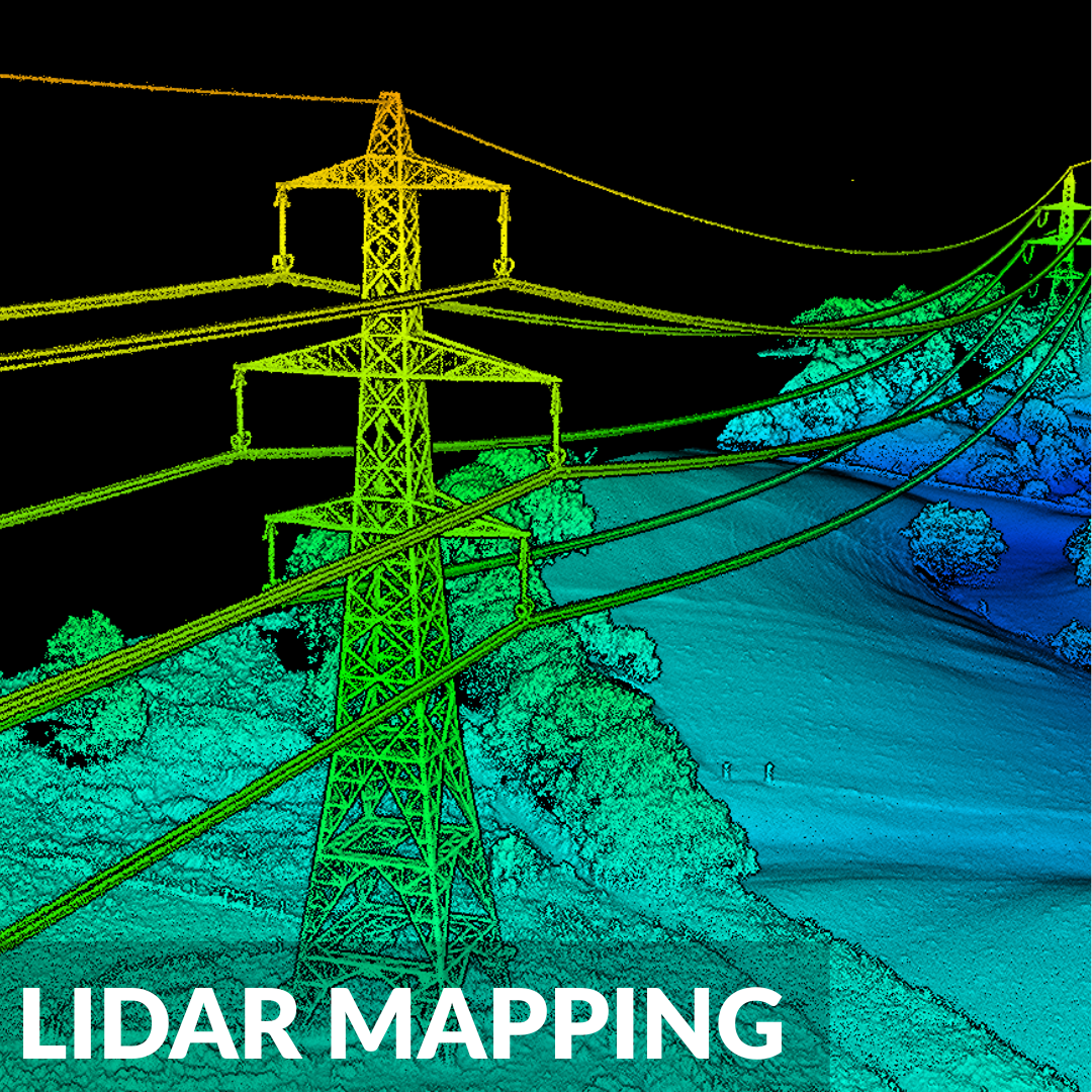
For assets requiring precise geometric data alongside condition assessment, our LiDAR capability delivers accurate point clouds and 3D models from the same mobilisation, removing the need for separate survey and inspection visits and reducing overall project cost and programme.
All infrastructure drone surveys are planned and executed by experienced survey professionals. Our pilots hold GVC certification and carry the relevant site safety qualifications for working within managed infrastructure environments including active construction sites and operational railway corridors. Every deployment is underpinned by site specific RAMS, CAA operational authorisation, and comprehensive public liability and professional indemnity insurance.
Infrastructure Assets We Survey
Vertex Air undertakes drone inspection and survey services across a wide range of infrastructure asset types. Our teams carry the specific technical knowledge and operational experience each asset type demands.
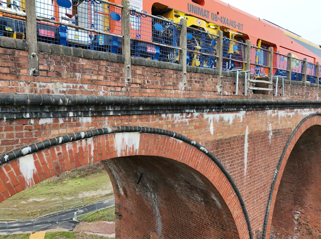
Bridges and viaducts Visual condition surveys, LiDAR mapping, and photogrammetry of road, rail, pipe, and heritage bridges, including external elevations, deck surfaces, parapets, and underside soffit inspection. Where internal voids require inspection, the Elios 3 provides complementary internal survey capability without the need for separate contractor engagement.
Railway infrastructure Drone inspection of railway structures including bridges, viaducts, tunnels, retaining walls, embankments, and OLE portals, capturing detailed condition data within possession windows or from safe standoff distances without disrupting operational services. Our teams carry the relevant competencies for working within managed railway environments.
Highway structures Condition surveys and geometric data capture for highway bridges, retaining walls, gantries, sign structures, and associated highway infrastructure, providing asset managers and local authorities with the condition data required for maintenance planning and capital works programming.
Powerlines and electricity transmission Aerial inspection of overhead powerlines, pylons, and transmission infrastructure identifying conductor damage, insulator defects, vegetation encroachment, and structural deterioration across extensive linear assets efficiently and without disruption to live networks.
Pipelines and pipeline infrastructure Above ground pipeline inspection for condition assessment, corrosion identification, and support structure survey — covering oil, gas, water, and district heating pipeline assets across both urban and rural environments. Thermal imaging available for subsurface leak detection in applicable asset types.
Telecoms masts and towers Visual condition surveys of telecoms masts, communication towers, and antenna structures capturing detailed close up imagery of structural components, fixings, and antenna arrays from a safe standoff distance without the requirement for mast climbing.
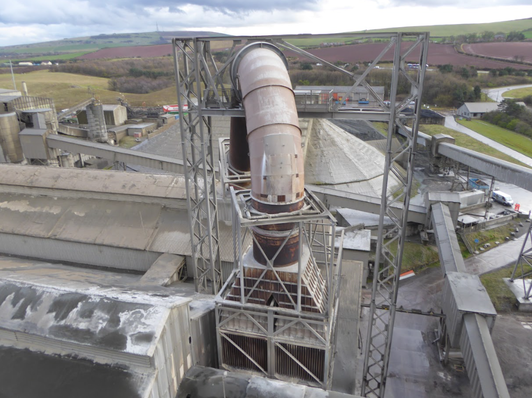
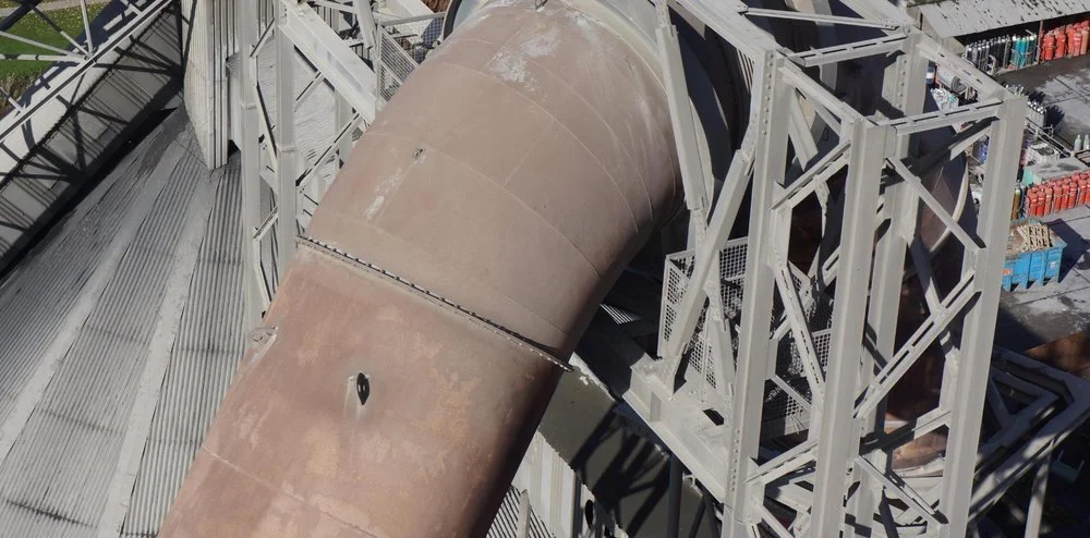
Industrial chimneys Visual condition surveys and thermal inspection of industrial chimney structures, flue linings, and refractory materials identifying deterioration, structural defects, and material loss from ground level without the requirement for scaffolding or mast climbing.
Wind turbines Blade and tower inspection of onshore wind turbines, identifying leading edge erosion, surface cracking, lightning strike damage, and structural defects across the full blade extent from ground level, with thermal imaging available for electrical fault detection.
Retaining walls and earthworks Condition surveys of highway and railway retaining walls, embankments, and earthwork structures capturing detailed imagery and geometric data to support structural assessment and maintenance planning.
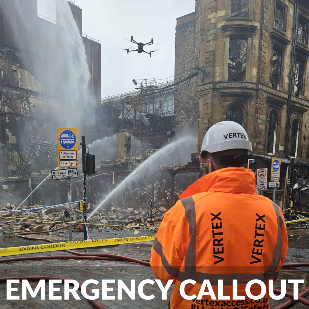
Emergency Callout and Rapid Deployment
Infrastructure incidents don't follow a programme. Storm damage, vehicle strikes, structural failures, and flood events can render assets unsafe at any time and the decisions that follow, whether to close a road, stop a train, or evacuate an area, need to be made quickly and on the basis of reliable condition data.
Vertex Air provides rapid deployment capability for post incident infrastructure assessment. Our teams mobilise at short notice to provide immediate aerial condition surveys of affected assets, delivering geo-referenced imagery, video footage, and where required LiDAR data to the engineers and asset managers who need it without putting personnel into environments that may be structurally unsafe.
Emergency callout surveys have been instructed following storm damage to highway and railway structures, vehicle strike incidents on bridges, and structural failures in industrial and heritage assets. In each case the drone survey provides the immediate data needed to assess risk, prioritise intervention, and brief response teams replacing the need for a person to physically enter or approach an unsafe structure before its condition is understood.
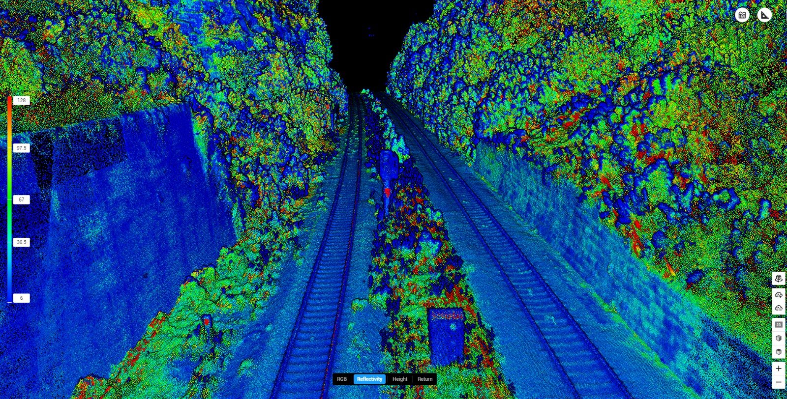
LiDAR Survey for Infrastructure
For infrastructure projects where precise geometric data is required alongside or instead of condition assessment, Vertex Air's LiDAR capability delivers survey grade point clouds from a single aerial deployment.
Utilising the Hovermap ST-X LiDAR scanner and DJI M350 RTK, our geospatial specialists capture highly accurate three dimensional data from infrastructure assets, producing deliverables suitable for structural analysis, CAD drawing production, BIM model creation, and as built verification.
This capability is particularly valuable for highway and rail infrastructure clients where dimensional accuracy is critical, and for heritage structures where a precise geometric record is required as part of a conservation or repair programme. LiDAR surveys can be conducted without lane closures or possession windows in many cases, significantly reducing the programme and cost implications compared with ground-based survey methods.
Drone LiDAR Surveys — our full external LiDAR survey capability
Who We Work With
Vertex Air's infrastructure inspection services are engaged across a broad range of sectors and professional disciplines.
Highway authorities and local councils — condition surveys and geometric data capture for highway structures, retaining walls, and associated infrastructure as part of planned inspection programmes and reactive investigation following reported defects or incidents.
Rail infrastructure managers and contractors — drone inspection of railway structures within possession windows or from operational standoff distances, providing condition data and LiDAR survey outputs for maintenance planning, renewal programmes, and structural assessment commissions.
Utilities and energy operators — inspection of powerlines, pylons, pipelines, and energy infrastructure assets across extensive linear networks, providing condition data to support maintenance scheduling and asset life management programmes.
Structural and civil engineers — condition data and geometric survey outputs to inform structural assessment, design, and specification work on existing infrastructure assets.
Local authorities and asset managers — planned inspection programmes delivering consistent, documented condition records across infrastructure portfolios to support maintenance budgeting and capital planning decisions.
Heritage and conservation consultants — detailed condition survey and geometric recording of historic infrastructure assets including listed bridges, viaducts, and retaining structures.
Insurance assessors and loss adjusters — rapid condition assessment of infrastructure assets following incidents, storm damage, or for routine insurance valuation and claims investigation purposes.
Other survey and inspection companies — specialist sub contract aerial inspection and LiDAR survey capability for practices requiring drone based data capture as part of a wider commission.
Operational Approach
Every infrastructure inspection begins with a desktop review of available information existing drawings, historical inspection records, asset registers, known constraints, and airspace and access restrictions. For assets on operational railways or highway networks, this includes liaison with the relevant infrastructure manager to establish the appropriate operational approach and any specific site requirements.
On site, a point of work assessment is carried out before deployment. Our GVC certified pilots operate the drone from a safe ground position throughout, with no requirement for personnel to work at height or within the inspection zone in standard deployments. For assets in restricted airspace or close to operational infrastructure, our CAA operational authorisation and established operational procedures ensure compliance with all relevant aviation and safety requirements.