Drone Internal LiDAR Survey Services
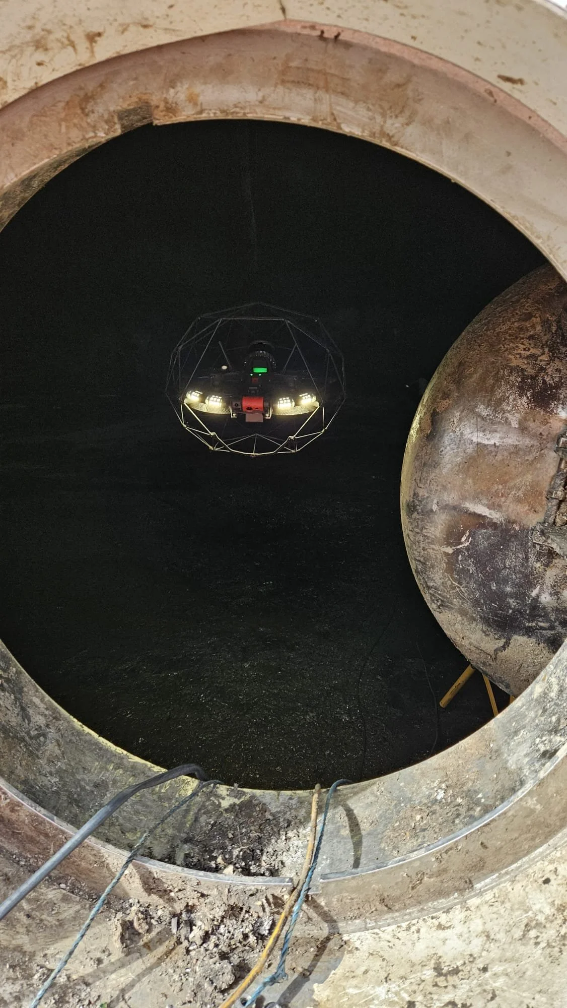
Vertex Air provides drone based LiDAR survey services for internal, confined, and inaccessible structures where conventional survey methods are impractical or unsafe. Deploying the Flyability Elios 3 with an advanced LiDAR survey payload, our geospatial survey teams capture precise, georeferenced point cloud data from environments that terrestrial scanners and total stations cannot reach delivering measured survey outputs suitable for CAD, BIM, heritage recording, and asset management applications.
Drone Based Internal LiDAR Survey
LiDAR, Light Detection and Ranging, is a remote sensing technology that measures distances by emitting laser pulses and calculating the time taken for each pulse to return. When mounted on a drone platform, LiDAR produces dense, three dimensional point clouds that accurately represent the geometry of the surveyed environment.
For internal and inaccessible structures, drone-mounted LiDAR offers a capability that no other survey method can replicate. Where a terrestrial scanner requires stable, accessible positioning and line of sight, the Elios 3 navigates freely through confined, unlit, and GPS-denied environments, capturing continuous LiDAR data from angles and positions that no human-operated instrument could safely or practically achieve.
The result is a comprehensive, spatially accurate digital record of the asset's internal geometry, suitable for a wide range of professional applications.
Our Survey Capability
Vertex Air deploys the Flyability Elios 3 with a dedicated LiDAR survey payload for all internal mapping applications. The system uses Simultaneous Localisation and Mapping, SLAM, technology to navigate and capture data without GPS signal or ambient light, making it suitable for the most challenging internal environments.
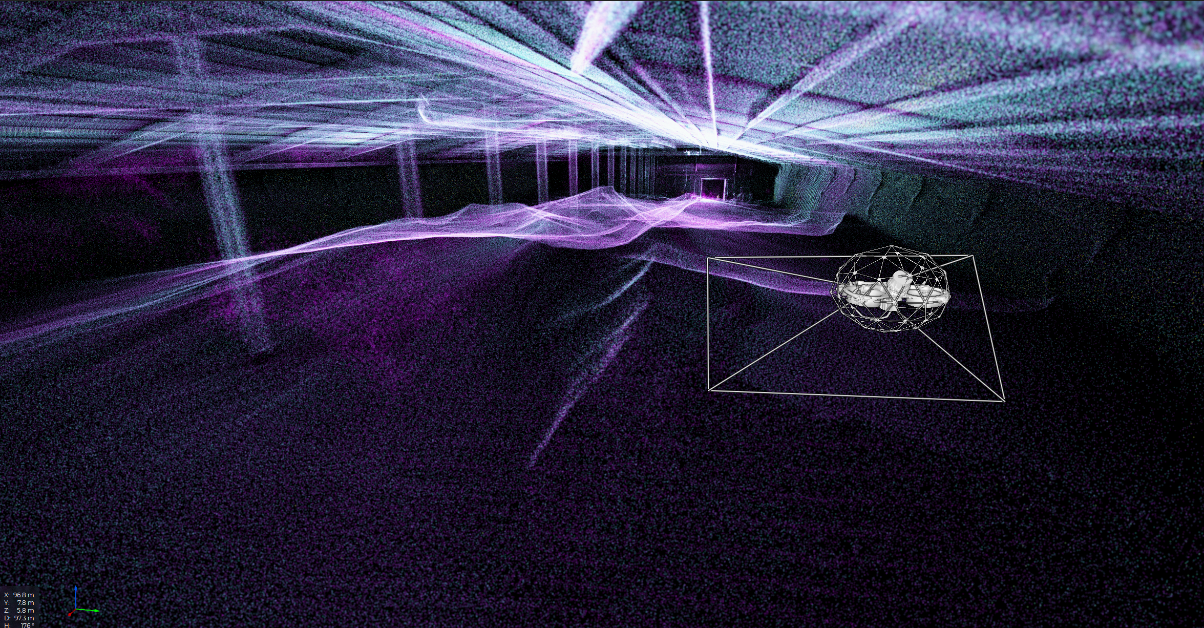
SLAM-based navigation The Elios 3 builds a real time map of its environment using LiDAR data, allowing stable, controlled flight in completely unlit and GPS denied spaces including deep underground culverts, storage tanks, and internal structural voids.
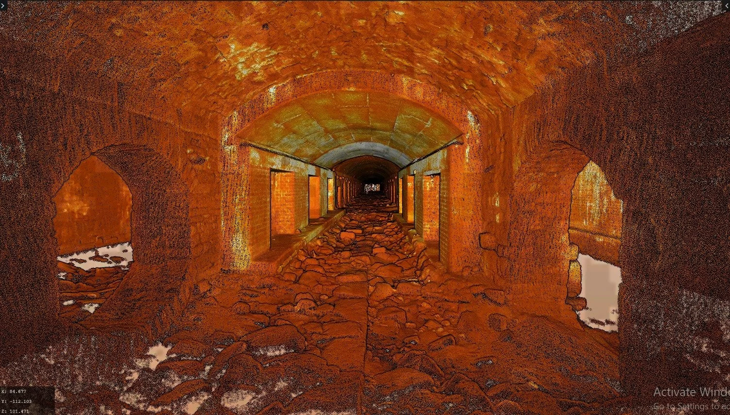
Dense point cloud capture Continuous LiDAR scanning throughout the flight path produces a dense, three dimensional point cloud of the internal environment, capturing wall surfaces, structural features, and geometric detail across the full survey extent.
Integrated visual data High resolution 4K imagery is captured simultaneously alongside LiDAR data, allowing visual condition information to be directly associated with spatial survey data within the same dataset.
GPS denied operation Unlike external drone LiDAR platforms that rely on GPS and RTK correction, the Elios 3 SLAM system is entirely self referencing, making it the appropriate tool for underground, indoor, and heavily occluded environments where satellite signal is unavailable.
Data processing and delivery All LiDAR data is processed by our geospatial survey specialists using professional survey grade software, producing clean, registered point clouds and derived outputs in formats suited to the client's workflow and application.
Survey Outputs and Deliverables
Drone internal LiDAR survey data is processed and delivered in formats directly compatible with professional CAD, BIM, GIS, and heritage recording workflows. Standard deliverables include:
Processed point cloud A fully registered, cleaned point cloud of the surveyed environment delivered in LAS or LAZ format, suitable for import into AutoCAD, Revit, Civil 3D, MicroStation, and other professional platforms.
CAD drawings Plan, section, and elevation drawings derived from the point cloud, produced to client specified scale and format, suitable for planning applications, structural assessment and further decision making.
3D mesh model A textured three dimensional mesh model of the internal environment, suitable for visual review, client presentations, and heritage recording applications.
BIM compatible model Where required, point cloud data can be used as the basis for a BIM model to the client's specified level of detail, suitable for integration into existing project information models.
Combined visual and spatial dataset Where 4K visual inspection data is captured alongside LiDAR, the combined dataset provides both geometric survey information and condition imagery within a single, spatially referenced record.
Specific deliverable formats, coordinate systems, and output requirements are agreed at project scoping stage. Our geospatial specialists are available to advise on the most appropriate outputs for a given application prior to mobilisation.
Applications
Drone internal LiDAR survey is applicable across a wide range of professional contexts. The common thread is the need for accurate geometric data from an environment where conventional survey access is impractical, unsafe, or disproportionately expensive.
Measured survey Capturing accurate internal dimensions of existing structures for renovation, refurbishment, or extension projects particularly where physical access for conventional survey is restricted or hazardous.
Structural assessment support Providing engineers and structural consultants with accurate geometric data to inform load calculations, deflection analysis, and condition assessment of internal structural elements.
Heritage recording Producing detailed measured survey records of historic structures, vaults, undercrofts, and inaccessible architectural features to the standards required for conservation and listed building applications.
Planning and development Supporting planning applications, pre-development surveys, and site feasibility assessments where accurate internal geometry of existing structures is required before design work can proceed.
Infrastructure condition mapping Mapping the location and internal geometry of culverts, tunnels, sewers, and drainage infrastructure to support maintenance planning, capacity assessment, and capital works programming.
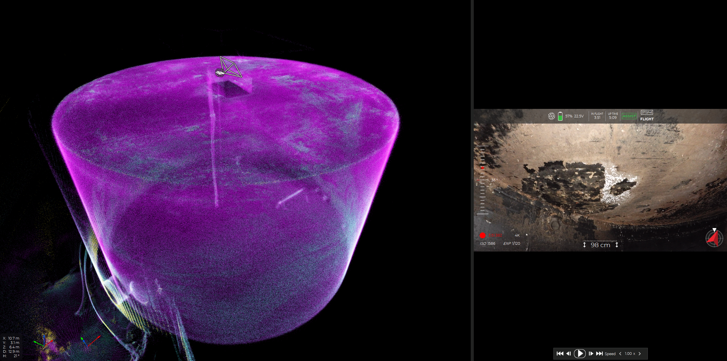
Volumetric calculation Calculating internal volumes of storage tanks, silos, voids, and irregular spaces where physical measurement is impractical, relevant for asset management, insurance valuation, and operational planning.
Environments We Survey
The Elios 3 LiDAR platform is deployable across a wide range of internal and inaccessible environments. Our survey teams have operational experience across the following asset types, and our geospatial specialists understand the specific data requirements each application demands.
Underground culverts and drainage LiDAR mapping of culverts from accessible entry points, capturing internal geometry, route, cross sectional dimensions, and structural features throughout the survey extent.
Sewer networks Geometric survey of sewer assets for capacity assessment, rehabilitation planning, and as-built documentation.
Tunnels Internal dimensional survey of railway, highway, and pedestrian tunnels, capturing geometry, lining profiles, and structural features with minimal or no operational disruption.
Storage tanks and vessels Internal geometry capture of bulk storage tanks, water reservoirs, pressure vessels, and silos, providing volumetric data and as-built records without confined space entry.
Industrial chimneys Internal profile survey of chimney structures and flue linings, capturing dimensional data and geometric deformation.
Bridge voids and internal structures Geometric mapping of box girders, abutment chambers, and internal bridge voids for structural assessment and as-built verification.
High level internal spaces LiDAR survey of atrium roofs, high level industrial structures, roof voids, and elevated internal environments where conventional survey access would require temporary works or powered access equipment.
Hazardous and inaccessible structures Geometric data capture from structurally compromised, fire damaged, or otherwise unsafe buildings where human entry carries unacceptable risk.
Who We Work With
Vertex Air's drone internal LiDAR survey services are engaged across a broad range of professional disciplines. Our geospatial specialists are experienced in delivering data to the standards and in the formats required by each.
Structural and civil engineers requiring accurate geometric data to inform assessment, design, and specification work on existing structures.
Architectural practices needing measured survey data of existing buildings, particularly where inaccessible or heritage elements make conventional survey impractical.
Heritage and conservation consultants requiring detailed internal recording of historic structures for conservation management plans, listed building consent applications, and archive purposes.
Infrastructure asset managers in highways, rail, utilities, and water sectors needing accurate condition and geometry data for maintenance planning and capital works programming.
Planning consultants and developers requiring pre-development survey data of existing structures to support planning applications and feasibility assessments.
Survey companies and geospatial practices seeking to extend their service offering into inaccessible environments through a specialist sub-contractor with the appropriate drone platform and operational experience.
Main contractors and project managers needing reliable survey data from within structures during or following construction, refurbishment, or demolition projects.
How Drone Internal LiDAR Survey Relates to Our Wider Services
Drone internal LiDAR survey is one component of Vertex Air's broader survey capability. Where a project requires both internal and external data capture, our teams can combine the Elios 3 internal LiDAR platform with our external drone LiDAR capability for above ground and external survey work, delivering a complete, spatially referenced dataset of the entire asset from a single mobilisation.
Where survey findings identify defects requiring physical inspection or remedial works, Vertex Air works directly alongside the specialist teams at Vertex Access providing a coordinated response from survey through to intervention without the need for multiple contractor engagements.
Confined Space Drone Surveys — our full internal inspection service including visual, thermal, and gas monitoring